| Well Mapping |  |
WellMagic grew out of a mapping
application so it is only natural that maps be an option. These maps will
not only help you find your way, they will improve your work. We are
value-added resellers for DeLorme products and offer XMap, TopoUSA, GPS units, and USA/Canadian Street
data.
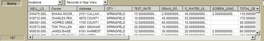
XMap allows you to see the locations of your wells as in the example below. This is key to better estimates and being better prepares at the drill site. These maps can also be printed out for inclusion with well completion reports. In addition, latitude, longitude and elevation data can be gathered from XMap.
Other uses of XMap include:
| Finding locations by street address or other ways. | |
| Identifying the fastest route to a location | |
| WellMagic wells can be added to the map views with a few clicks of the mouse. | |
| Gathering Latitude, Longitude and Elevation data | |
| Township/Range and section information can
be added to the map as well as other special data such as Water Management District or county/city boundaries. | |
| In some states, aerial photography is
available for inclusion. The possibilities are endless! |
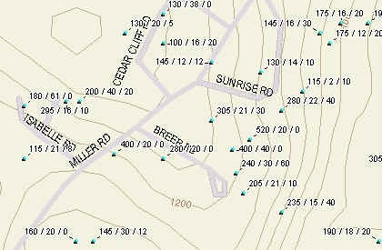 |
This sample map is in Vermont and shows wells
in an area. The points show Depth/Ft of Casing/Static Water
Level. Elevation contours are included as are the all
streets. The mapping module is not required to run WellMagic but you can see it has many advantages. The map will include all roads in your territory so it can be used for driving directions. Most states have their well logs available so that Xmap can be ready to go with tens of thousands of wells already on it. XMap allows you to see the entire world or you can zoom into an area as small as a few square feet. Of course, everything in between is available too! The more you zoom in, the more detail you see. |
|
|
||
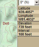 |
This section of the screen shows the latitude, longitude, and elevation of the cursor. While not as accurate as a GPS reading, this reading is superior to a sketch or SWAG! | |
Back to WellMagic